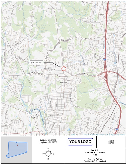
DIY Report Figures can be generated online on aerial, street or topography background maps, with or without additional survey points and lines.
DIY Maps can be used for any project requiring site maps or topographic maps. Simply add client, add site, site address, Lat, Long coordinates, and generate figure online, including title block, site information and your logo. First figures are FREE!
Survey information to maps can be added in four different ways:
- manually, entering point Lat,Long coordinates,
- uploading a csv file,
- uploading a GeoJSON survey file,
- as LOGitEASY boreholes (using the field logging eForm)
LOGitEASY online figure service is priced on per-figure or subscription basis. If using pay-as-you-go plan, you can purchase sets of 5 different zoom figures at a discount ($20/set of 5 figures).
For those who conduct regular Phase I and Phase II Environmental Site Assessments (ESAs), we now offer our DIY Report Figure service on monthly or annual subscription basis. The cost effectiveness of the subscription depends on a number of figures you create.
-
PAY-AS-YOU-GO
$10*/figure - aerial/street/topo background
- five zoom levels
- upload & display survey points
- Request set of 5 figures for $20
- *$15 for analytical figures and contour maps
-
Subscription - billed monthly
$99/month - all pay-as-you-go features
- 200 figures/month/user
- export & conversion - dxf, shp, kml, etc.
- Request custom drafting
($50/hour) - SUBSCRIBE
-
Subscription - billed annually
$49/month - all pay-as-you-go features
- 2,400 figures/year/user
- export & conversion - dxf, shp, kml, etc.
- Request custom drafting
($50/hour) - SUBSCRIBE
Bundle pricing
-
Block of 20
$150 - 20 DIY Site Figures
- Valid for 2 months
- Purchase
-
Block of 40
$200 - 40 DIY Site Figures
- Valid for 3 months
- Purchase
Please contact us for Enterprise Pricing Plans.
DIY Figure Examples