"With your process I can have my assistant order maps without me sitting on Corel and drawing them. Very Easy!"
Project Manager, Azusa, CA
LOGitEASY DIY mapping service allows creating site topography and aerial figures online, including company logo, figure title, site address and titleblock, without special GIS or graphic software knowledge.
You can also choose to display property boundary instead of a site location circle. Parcel boundary data are obtained automatically from our online property database (USA).
This GIS mapping service is used for planning field work, for Phase I and Phase II Environmental Site Assessments, as well as for any other industry reports requiring maps and figures.
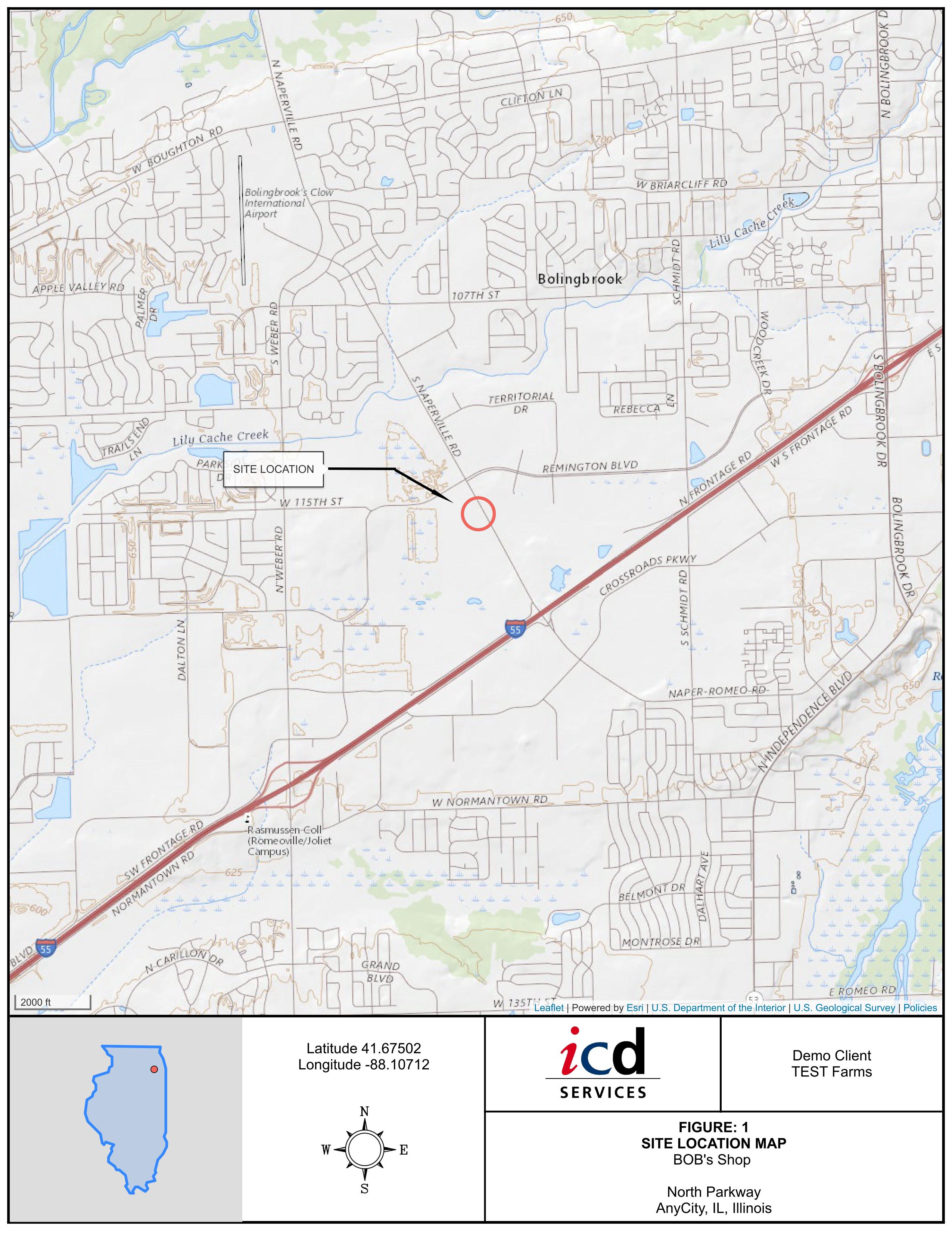
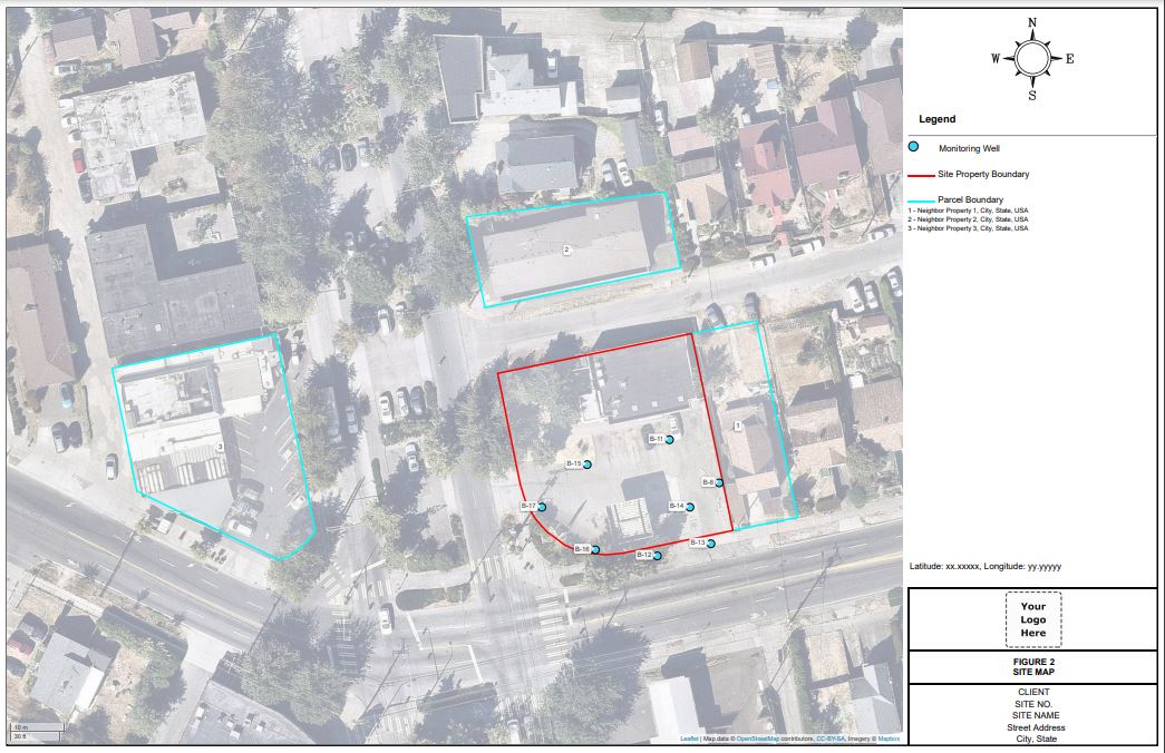
Site Maps and Site Location Maps can be generated in 5 different zoom levels, on aerial, street or topography background, with or without survey information.
Survey information (boreholes, underground utilities, underground storage tanks, excavations, etc.) can be added to site figures in four different ways:
- Add Lat, Long coordinates to boreholes completed using the LOGitEASY eForm
- Add additional survey points manually, by entering Lat, Long coordinates
- Upload individual survey point coordinates as a csv file
- Upload survey information of points and other features as GeoJSON files
- You can also add property lines and neighboring parcel boundaries by selecting their location on a map (USA).
Once the points and lines are added, select linetype, symbol, color and create figures online.
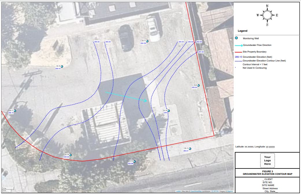
Groundwater Elevation Contour Maps can be generated online using location data of previously logged LOGitEASY monitoring wells or using manually added or uploaded survey points.
Simply add a site (project), upload monitoring well IDs, well coordinates and groundwater elevations, and create automatic groundwater elevation contour maps online in minutes.
Well coordinates can be uploaded in csv file format, as Lat/Long, State Plane or UTM coordinates.
Groundwater flow direction arrow can be added manually.
Let us know if you require georeferenced groundwater contours, monitoring wells or property parcel boundaries. We can provide geolocated dxf, geoJSON, etc. format files in multiple coordinate systems for use with CADD, GIS or 3D modelling tools.
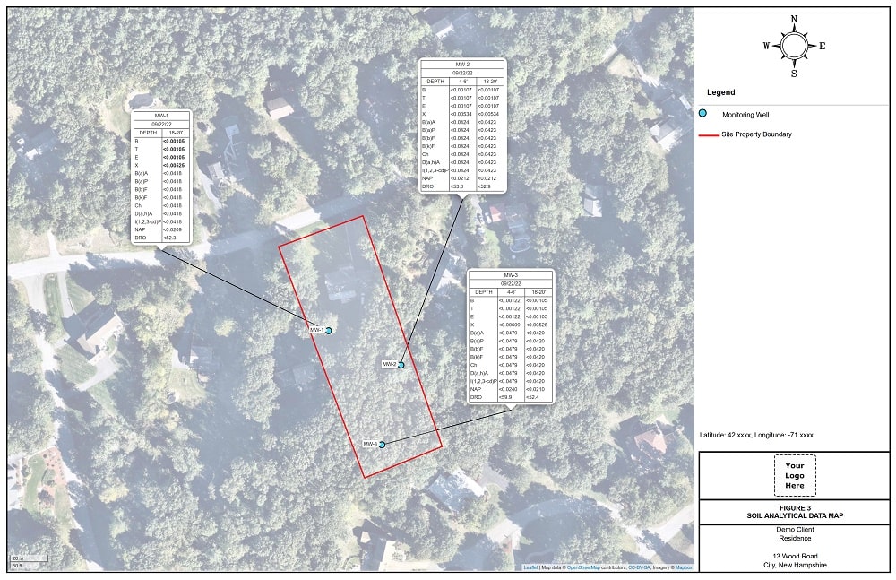
Soil and Groundwater Analytical Figures can be generated online by copying formatted analytical data from MS Excel or other data management software, and placing them on an aerial, topo, or other map background. Data tables can then be moved and customized according to your preference.
Simply add a site (project), add manually or upload boring or well locations and IDs, paste analytical data from your preferred data management software, and create analytical figures in seconds. Borehole coordinates can be uploaded in csv file format, as Lat/Long, State Plane or UTM coordinates.
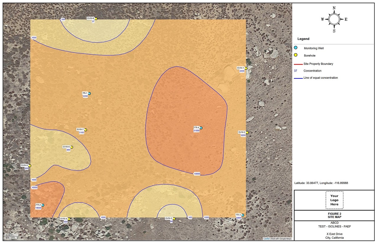
Isoconcentration and heat maps can be generated online with a few clicks. Isolines are created using previously logged boring locations or manually added or uploaded survey points and comtaminant concentrations.
Simply add a site (project), upload or add borehole locations and contaminant data and create automatic isconcentration and heat maps with a few clicks.
Boring coordinates can be added manually, uploaded in csv file format, as Lat/Long, State Plane or UTM coordinates.

Add image overlays and adjust those overlays to fit the aerial or street backgrounds.
Very easy way to show images of engineering line drawings, field sketches, proposed or historical buildings, site features, etc.
Once the image overlays are added, adjust rotation, scale, and opacity, retrace historical site details, piping, USTs, add former buildings, monitoring well locations.
Paste analytical data box results from MS EXCEL or other data sources.
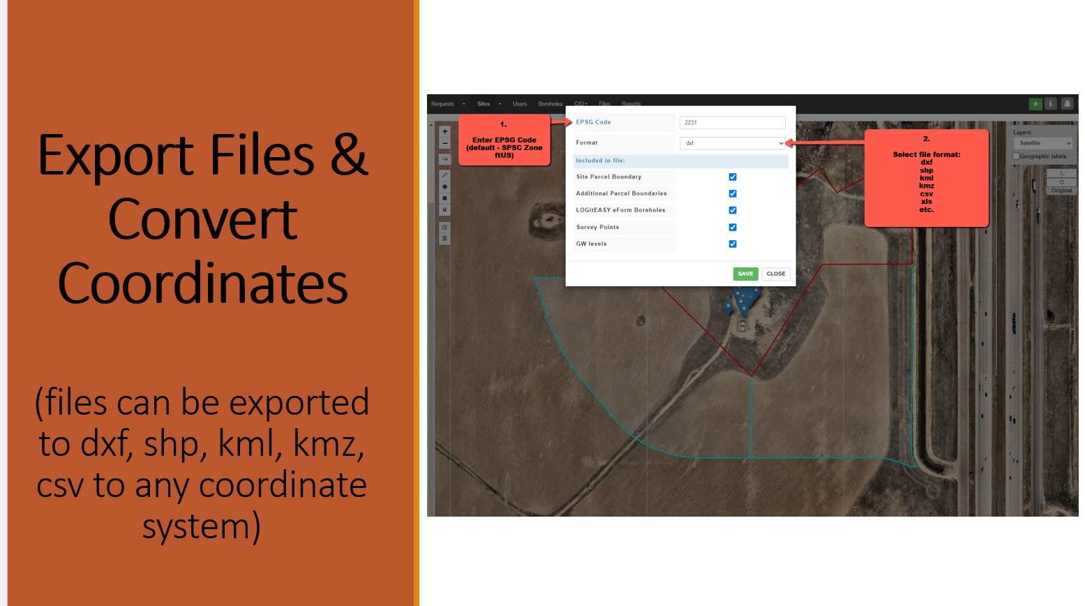
LOGitEASY GIS software allows converting property boundaries, boring locations and survey points into various formats (dxf, shp, kml, etc.) and coordinate systems, e.g. to show property location in SPC (ftUS) or UTM (metric) coordinates in AutoCAD, Google Earth, or ESRI in their correct coordinates.
Available export file formats : dxf, shp, kml, kmz, geojson, gml, gpx, mapinfo, dgn, gpkg, sqlite, csv, ods, xlsx.